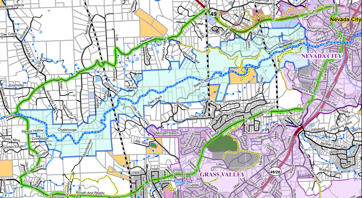
About the Project
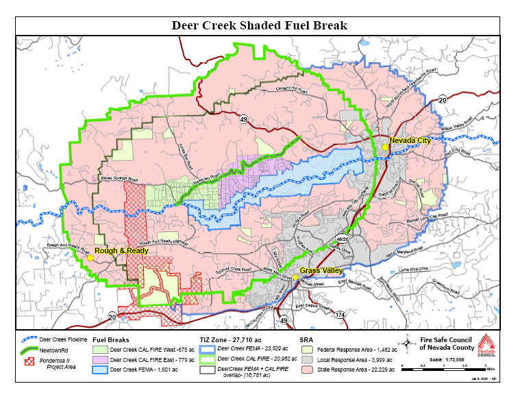
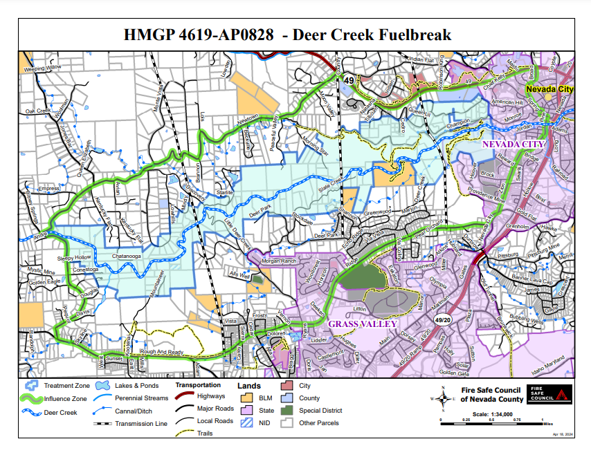
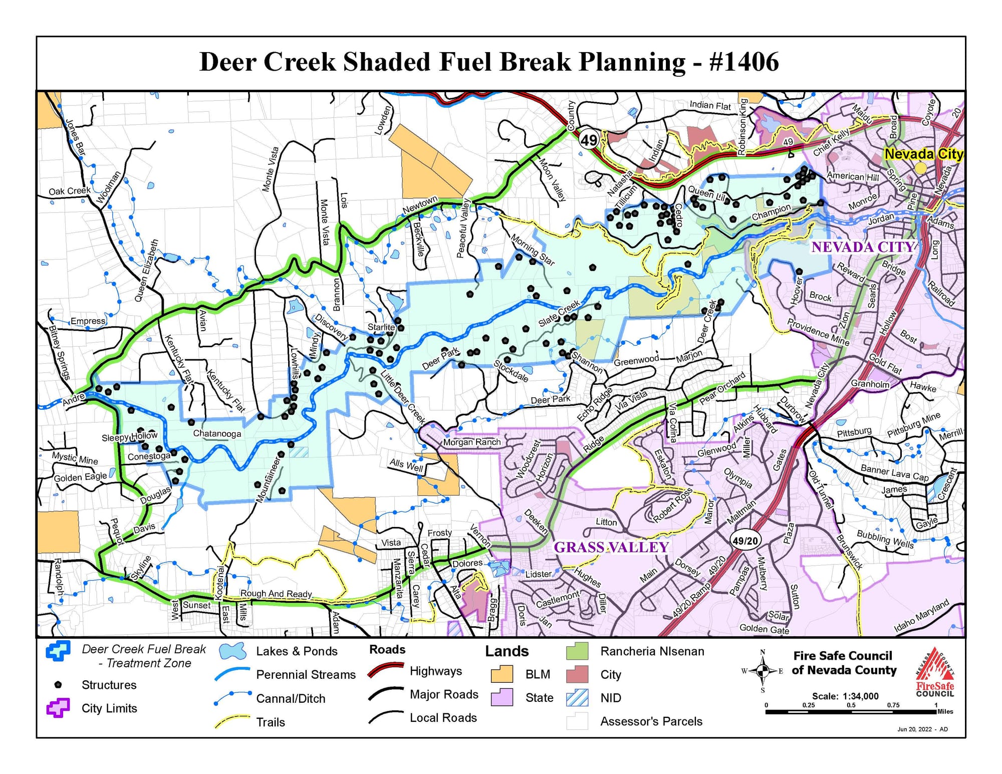
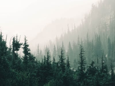
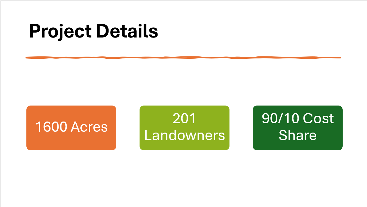
The Deer Creek Canyon Shaded Fuel Break will remove and reduce fuels on 1600 acres in Deer Creek canyon to make our community safer from wildfire.
A shaded fuel break involves thinning vegetation, especially ladder fuels, to slow down the speed and intensity of a wildfire. It gives firefighters a better place to fight the fire. Many trees and their shade will be retained. It is not a bare earth “fire break”.
It will improve wildfire safety for Deer Creek Canyon, Nevada City, and Grass Valley. The more neighbors who participate, the safer our overall community will be. Retired Cal Fire Battalion Chief Matt Wallen has stated it is the single most effective intervention for protecting our area from wildfire.
Landowner participation is voluntary. Participating landowners are required to match 10% of the implementation cost for their property, which they can meet in three ways: by working on the property themselves (valued at ~$38/hour), through their expenses for maintaining it, or cash. Owners must agree to maintain the treated property for 10 years.
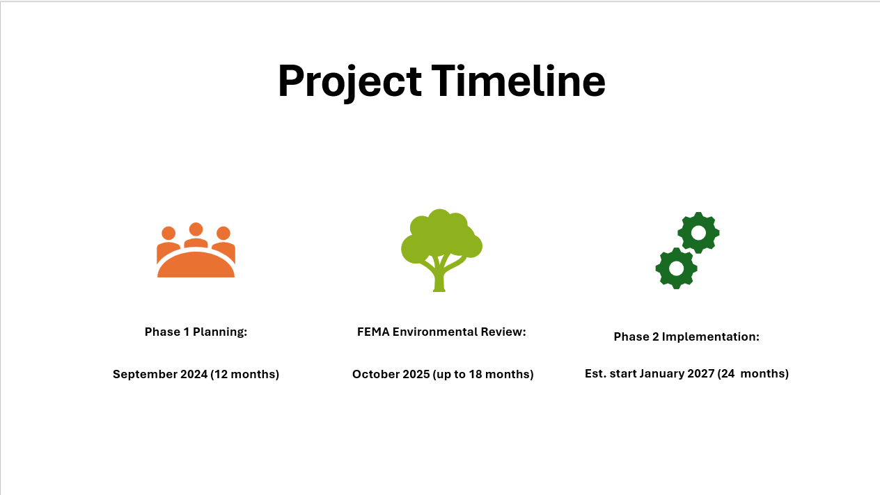
In the project’s Planning phase, a licensed forester will work with each owner to develop a treatment plan specific to their property. This phase, started September 1, 2024, will last approximately 1 year. The Federal Emergency Management Agency (FEMA) and the California Office of Emergency Services (CAL OES) will review the planning materials for approximately 12 to 15 months. Then, the implementation phase will run for about two years.
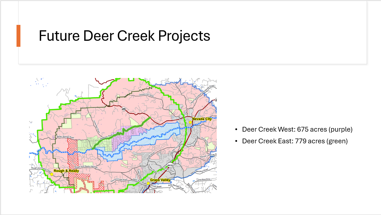
This project is being developed and managed by the Fire Safe Council of Nevada County. Six Firewise communities and Nevada City Fire Safety Advisory Committee support the project. Deer Creek Canyon Shaded Fuel Break is part of the Fire Safe Council’s regional plan for fuels management projects in our area. The next project is the Deer Creek Ponderosa Connection along Newtown Rd. (This project is labeled on the map as Deer Creek Cal Fire East and Deer Creek Cal Fire West.) This project is not yet funded.
A shaded fuel break involves thinning vegetation, especially ladder fuels, to slow down the speed and intensity of a wildfire. It gives firefighters a better place to fight the fire. Many trees and their shade will be retained. It is not a bare earth “fire break”.
It will improve wildfire safety for Deer Creek Canyon, Nevada City, and Grass Valley. The more neighbors who participate, the safer our overall community will be. Retired Cal Fire Battalion Chief Matt Wallen has stated it is the single most effective intervention for protecting our area from wildfire.
Landowner participation is voluntary. Participating landowners are required to match 10% of the implementation cost for their property, which they can meet in three ways: by working on the property themselves (valued at ~$38/hour), through their expenses for maintaining it, or cash. Owners must agree to maintain the treated property for 10 years.
In the project’s Planning phase, a licensed forester will work with each owner to develop a treatment plan specific to their property. This phase, started September 1, 2024, will last approximately 1 year. The Federal Emergency Management Agency (FEMA) and the California Office of Emergency Services (CAL OES) will review the planning materials for approximately 12 to 15 months. Then, the implementation phase will run for about two years.
This project is being developed and managed by the Fire Safe Council of Nevada County. Six Firewise communities and Nevada City Fire Safety Advisory Committee support the project. Deer Creek Canyon Shaded Fuel Break is part of the Fire Safe Council’s regional plan for fuels management projects in our area. The next project is the Deer Creek Ponderosa Connection along Newtown Rd. (This project is labeled on the map as Deer Creek Cal Fire East and Deer Creek Cal Fire West.) This project is not yet funded.
Deer Creek Canyon Project Maps
Treatment Overview
Treatment guidelines will be similar to those of the Ponderosa West shaded fuel break but may differ depending on the funding source that is ultimately selected.
At this point in time the examples below from Ponderosa West are theoretical only.
Remove live and dead fuels to eliminate fuel ladders, decrease horizontal and vertical continuity of flammable vegetation, decrease flammability, and accelerate decomposition. Healthy small trees and chaparral will be spaced to help prevent fire spread from canopy to canopy.
On tree-dominated sites, average stand density after treatment will be approximately 75-100 basal square feet per acre (see Q&A page for more info). On brush-dominated sites, at least one bush or group of bushes will be retained at most 100 feet apart. On poorly vegetated sites, one bush or group of bushes will be retained at most 30 feet apart.
Conifers greater than 12 inches in diameter at breast height, hardwoods greater than 10 inches diameter at breast height, and brush greater than 8 inches stump diameter will be retained if deemed safe and spacing allows.
Wildlife trees, snags, and/or large woody debris will be retained as important elements of value to wildlife. The SFB will retain at least one per acre averaged across the treatment unit.
Soils, site factors, and timing must be suitable for equipment to avoid excessive compaction, rutting, or damage to soils surface.
Manzanita is a target for removal due to its high burning intensity and ability to send embers a long distance. Large bushes with trunks greater than 8 inches will be retained when spacing allows.
Oaks are not a target species and will be retained for shade and habitat if they are healthy and spacing allows. Multi-trunked oaks will be thinned to promote canopy growth.
McNab cypress, if it exists in the treatment area, will be retained and limbed up to six feet, and young trees will be thinned.
Non-target plants such as coffeeberry, redbud, silk tassel, and toyon will be retained for wildlife food and cover, as spacing permits. These species are not highly flammable.
Riparian overstory trees will be retained as much as possible for shade. Riparian vegetation such as willow, cottonwood, redbud, dogwood, and the like will be retained.
No fuel piling or burning will occur in waterways.
Join our email list
Property owners that live within the project boundary can fill out this form to express interest in participating. This form does not legally commit or bind you to anything. It is simply a way for you to let us know that you might like vegetation removal on your parcel. Again, this is only for those folks that own property within the boundary of this project outlined on the map page.
You've already responded.
You can submit this form only once.Rare and Endangered Plants in Deer Creek Canyon
Rare and Endangered Animals in Deer Creek Canyon
Property Owner Permissions
Property Owner Right of Entry Permit
If you fall within the project foot print, please download and fill out the Right of Entry Permission
Registered Professional Forester Services Request
Registered Professional Forester Services (RPF)
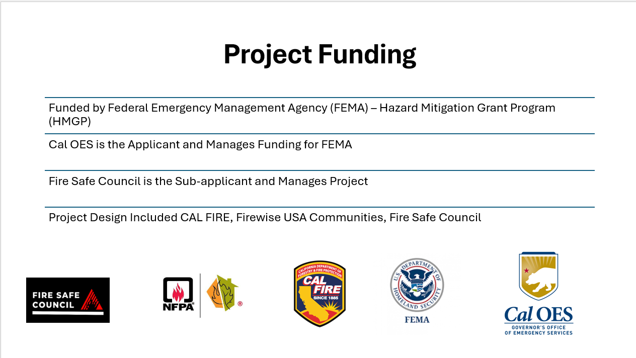
We are pleased to announce the release of the Request for Proposal (RFP) for the HMGP DR 4619-828-008 Deer Creek Shaded Fuel Break project. This project is funded through the Hazard Mitigation Grant Program (HMGP) and aims to reduce wildfire risk and improve community safety through the strategic implementation of a shaded fuel break in the Deer Creek area. We invite qualified contractors and firms to review the RFP and submit proposals in accordance with the guidelines and deadlines outlined in the document.
FireWise Community Collaboration
The following Deer Creek Canyon Firewise Communities joined together to support the Deer Creek Canyon Shaded Fuel Break Project. They are:
- Greater Champion (GCNA)
- Deer Creek South Side (DCSS)
- Foxwood-Slate Creek
- Echo Ridge
- Kentucky Flat
- Mountain Lake Estates
- Nevada City Fire Safety Advisory Committee*
This link will allow you to see a detailed map of each Firewise Community https://www.areyoufiresafe.com/programs/firewise-usa
* Nevada City Fire Safety Advisory Committee is not a Firewise Community
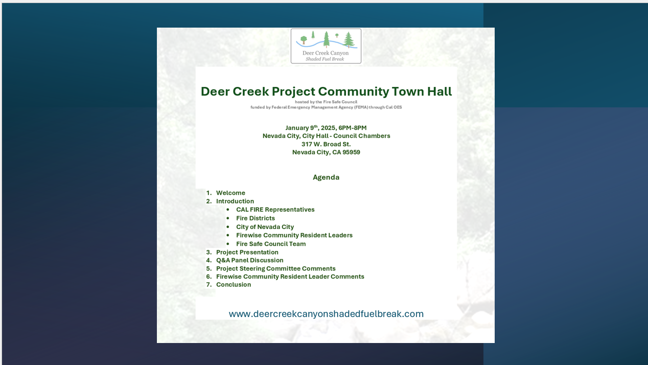
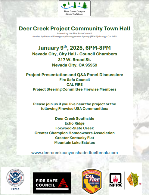
Town Hall Meeting Slide Deck

Q&A From Town Hall Meeting
How do you identify trees that will be removed?
Generally, the way this happens is, a prescription is written and trees that should be removed will be marked by an aluminum tag and nail. They are trying not to use paint and marking ribbon that can fly away. The Registered Professional Forester (RPF) will have a prescription written but the homeowner will be able to specify which vegetation they would like to keep by tagging it.
What about manzanita?
The scale of treatment is that we want to remove anything that is flammable, anything that’s going to allow that fire to establish further up into the crown and then move horizontally across the landscape. So, we really look at modifying the vertical and horizontal density. Now that doesn’t mean removing all manzanita, but it does mean keeping the manzanita in a condition where the fire can’t transfer from the ground into the canopy and can’t move across the landscape. And to establish that, the manzanita needs to be pruned: remove all dead limbs to create spacing and rake underneath so there is no ground fuel.
Item #13 on the Right of Entry permit, the Maintenance and Match Verification; what exactly does that involve?
FEMA requires that you maintain the initial implementation work that they have invested in for 10 years. By signing the second maintenance agreement as the resident or homeowner you agree to keep the treated area maintained for 10 years. The Match verification letter states that the owner agrees to the 10% cost share match, and you can track it in the In-Kind volunteer work you can contribute instead of cash money into the project or pay for the 10% of the work. We would need you to annually commit to track that time or cost. Basically, two supplemental documents, one stating that yes, you will maintain this investment for 10 years because FEMA requires that of us and the second saying that yes you will annually turn in your time commitment or the cost amount that you have extended as part of the 10% match – cost share.
And is that 10% from the initial 90 / 10 cost share?
Correct, the 10% in the 90 / 10 cost share will be valued at the initial 10%.
Basically the 10-year maintenance is something we are responsible for, we’re responsible for taking care of the cost and doing the work?
Correct the 10-year maintenance you are responsible for but if it falls within the 2 years of implementation. Your maintenance can qualify as your 10% cost share. If you’re tracking your time and your maintenance on your parcel, annually keeping up on your defensible space, that can qualify as your 10% cost share.
With property on Deer Creek will the work cover only specific zones or cover the entire property?
There will be minor setbacks with property on the creek, where we cannot work in the watershed itself. We will probably have anywhere from 100 to 300 feet of setback. The project accounts for defensible space and fuels reduction on the entire parcel. But what that implementation, and that treatment looks like may be vastly different from your defensible space zone to your back 40. You may not want it to be as well as peeled back as long as it meets the requirements of the grant in the prescription. That’ll be for the forester to decide. But yes full parcels.
If you choose to do your own work on your property, can you be reimbursed for that or not?
FEMA does not allow that because of their procurement processes. We have to go out to a fair bid for the vendors who are going to do the contract work. It will be 1 of 2 things, it’ll either be Fire Safe Council crews or a contractor crew. FEMA does not reimburse you for the work if you do your own work.
What happens to the residual material that’s there?
That’s going to vary by prescription as well. This project does not account for us pulling vegetation off site right now but if the forester says that’s what needs to be done on your parcel, it will be up to the forester and / or the contractor with their L.T.O. license to make sure that those rules are followed. In general, material can be chipped and left on site.
Will there be coordination between parcel owners when it comes to treatment?
Each parcel will have different prescriptions according to defensible space. Especially if one parcel’s back 40 is impinged on another’s defensible space. The forester will try to achieve your defensible space in the prescription and legally the neighbor has to give you your defensible space. This is about collaboration and coordination. We would love to see parcel owners introduced to each other and connect so that they can know their neighbors.
If this is a reimbursement grant and given the fact that the Fire Safe Council has to pay for the work to be completed before we can get reimbursed, how does that work out with your financial resources currently?
It’s a concern. It’s always a concern we are a 501(c)(3) nonprofit. We don’t have a tax base to work off of, we don’t have County funds to work off of. The Board has been very diligent in working with the staff as we try to navigate to get through some unpaid invoices and money owed. We are working through it and we’ve met with the steering committee members multiple times because that’s a question and concern for everyone. We’re confident that we’re going to navigate, we would not have signed our contract and committed to do the work if we didn’t have a path forward. We will be working with contractors that will know that we won’t get paid unless we pay them.
Where does the 10% fit into the cash flow conversation?
Each parcel is invoiced out at a certain amount. So, whether it’s a contractor or it’s Fire Safe Council performing the work, that parcel owner will receive an invoice for the total amount of services. There will be 10% off the top and that will be what the owner owes and that can either be matched by cash payment or matched with your match verification letter and your In-Kind volunteer time.
Does the contractor send the invoice to you, and then you invoice the property owner or does the contractor do the invoicing?
The contractor will be a contractor of the Fire Safe Council. So, yes, then they’ll send it to us and then project management will share it with the owner.
The forester comes out in the planning phase. Do they give us the estimate then?
The forester may not know what the estimate is because they are not the contractor. We might have a pretty good idea of what the cost may look like at a price per acreage by treatment. Fire Safe Council or our contractor might be able to give you an estimate, but we won’t know until we get to the implementation phase. We might be able to give you a rough estimate.
My property is within the area of the proposed shaded fuel break. I am the owner, but the property is also a conservation easement but is controlled by restrictions of the land trust easement. Does this preclude inclusion or require the land trust to
I’m hesitant to answer that question because I don’t know who the conservation easement is through. I will definitely have to get an answer though, but it will have to be a 3 way conversation of what that treatment will look like because they have a conservatorship on the parcel.
I’m curious: 10% of what? If I’m committing to something, what am I committing to?
You are committing to, once we get that prescription, the forester and you agree on what that treatment looks like, you’ll be committing to 10% of the cost of that treatment.
And I can’t find out now [what the cost would be?
We will try to give you a rough estimate now. But I can’t say that the same price is going to stand in 2 years. The price can change from $2000 an acre to $5500 an acre. It just depends on the project. And the Deer Creek canyon has very dense vegetation, steep slope, it’s a lot of costly work. So, what we intend on doing is to follow up with them, the original prescription in the implementation phase and going back to each landowner, to make sure that they are still committed to getting a firmer cost estimate. We’re going to go back to the landowner to make sure everyone’s on the same page, the prescription still stands for you. You might have vastly different needs in 2 years, and then we’ll review that process to it and sign a new right of entry.
How were the parcels selected for participation in the program?
It was just a delineation for the best possible operational benefit in reducing the building of the potential of fire traveling up the drainage. We didn’t want to only include 3 acres of a 10 acre parcel, we included the whole property. It was designed with thought of fire behavior analysis.
If the total cost of the project is 7 million plus and we have the acreage, what was cost figure based on when writing the grant? And what was that figure?
We applied for this grant 3 years ago so at that time $2500 an acre and we are well over that now. That’s why the funders recognized that they understand that markets change, and the value of services changes. We have to go back to them with an answer of what is it going to cost now? And we have to think of in the future, what do we think it’s going to cost us 2 years in the future?
Is there a minimum property participation rate on this project?
The answer is no, and while we want everyone to participate, we want to chase down more funding so that everybody can participate in this, if it does go over budget. In the event that it doesn't, not everyone participates, that leaves a little money on the table to hopefully negate other costs, but we want everybody to participate.
Do you have an example when you did another district, another grant, just like this, what was the property participation rate?
It varies we ‘ve done them in different models. In Ponderosa we had about 70 to 75% landowners that participated. We also had South County project participation rate, and it was modeled a little different, a different type of treatment, mainly evacuation route clearing and not as much participation.
We have a lot of property owners that own more than 1 parcel and if they do more work on 1 more than the other can we bundle them together for the 10% match?
I don’t have the answer to that. It is supposed to be on a parcel-by-parcel level. I think that’s going to be how the homeowner reports their work.
Once we sign the contract, at what point will we be able or unable to backout?
You can backout at any time. Once we get to the point of having implementation work happening and we’re incurring large amounts of dollars, that might be a more difficult conversation. There is a clause [in the right of entry] that says that the landowner can reset their right of entry and contracts with formal written notice at any time.
As a part of a Firewise community, we’re required to do work every year to maintain that, does that work count towards this?
Yes, that time can be invested and matched to this project as long as it’s not matched to another grant-funded project. So, if your community has committed to another match, you can’t use that investment on this project. You can’t match it to FEMA and then match it to Cal-Fire.
On the other hand, many residents of Firewise communities report the time and money they invest in fire safety. This is part of being a Firewise community. It’s OK to count this investment both places as long as it is not applied to another grant project.
On the other hand, many residents of Firewise communities report the time and money they invest in fire safety. This is part of being a Firewise community. It’s OK to count this investment both places as long as it is not applied to another grant project.
Can you do this project over the top of a harvest plan? Cause I know normally you can’t do two plans at the same time.
The timing of when groundbreaking work starts for FEMA, we can’t have any other groundbreaking work happen, any implementation work on that parcel. Once under the prescription, you can’t be actively working off your THP [timber harvest plan] and then come back and fund it with FEMA. It could violate the entire process opportunity for everybody.
Is this running down a creek, what is that blue line on the map?
Yes that is what the blue line is on the map.
But you just finished saying that you can’t do work near waterways?
There are setbacks in the forest practice rules depending on what watercourse or what class it is so we would be 100 - 300 feet back. You can do work in there and sometimes you only do certain kinds of work. While it looks like it’s narrow it’s really a far setback from the creek.
How do you access it if it’s not?
The project was designed so that we did have access to everything, some of it will be very steep terrain and will be difficult to navigate. But when Cal-Fire came in to give us the final layout, you can see that the parcels are stacked near access roads, and evacuation routes. We had to have some tough conversations about who to exclude. There were targeted areas that were really important for the community that needed work. Some suggested that we’ll just move the line here, but we can’t because we can’t access it. It is landlocked, there is no easement, there are several issues.
At the end of this meeting what happens next? What are the outputs and follow-ups to this meeting? Can individual parcels be partially treated, if a property owner can’t contribute the full 10% match?
To answer the second part of the question, that would be a conversation to have with the parcel owner and the forester about what they’re trying to achieve. Not all parcels can be treated 100% of the time. We’ll start sending out more communication to the property owners. The goal is to get as many right-of-entries back from participants. If anyone has more questions our staff is available at any time.
How do you assess the price of the maintenance for 10 years?
The contract isn’t written in such a way that the maintenance has a value. It’s written in a way that the homeowner is supposed to maintain it. And depending on the parcel and the vegetation on that parcel, 3 to 5 years is the maintenance interval. We could give you an estimate of what we think, but it is not really valued, it’s more about you committing to maintaining it. As we exited other projects, we’ve tried to leave landowners with resources. Whether it was a roadside chipping program or green waste drop-off event. We try to present resources to landowners that make the 10-year maintenance commitment achievable.
What if I move after 5 years?
If the property changes hands, the maintenance agreement is null and void. The new owner does not have to assume the maintenance agreement.
For general access to the property, beyond key or gate codes will there still be 48-hour notice?
If we can’t reach the owner and schedule a site visit, we’re not just going to show up. We want you to be there during the inspection, even when we return to do the implementation. We will be reaching out to you making contact, viewing the property and making sure that everybody is still on the same page and then we schedule it when it’s convenient to you.
Some people live out of state, can they just say “go ahead” or have a designated rep?
They can if they feel comfortable with that. Some homeowners will have renters on the property, and we’ll need the contact info for the renter on the parcel to be able to communicate with them. Then they would have to sign off saying that the owner has given the renter authority to act on their behalf.
There is a big piece of BLM land near our house, we and our neighbors would love to know if that land will be treated?
Several of those BLM parcels have completed NEPA (National Environmental Policy Act). The problem with this funding is that it’s federal funding, and you cannot use federal funding to treat federal land. We have been working with BLM to make sure that we have the environmental compliance complete on these parcels, so that when opportunities do arise. We have partnered with Sacramento Regional Conservation Corps, AmeriCorps, other entities and agencies so that we have other pots of funding to allow us to treat those parcels. The goal is to get those environmental compliance documents fully completed, and then get the go ahead for BLM, and we are working with them, so that we can find those pools of funding to cover those treatments.
What if we sell our property after the planning phase and before implementation occurs, would that owner be excluded from the project?
We can roll over as long as the prescription and the surveys have been completed. We can roll over prescriptions to the new owner. However, we would still have to secure a new right of entry and make sure that the new owner is on board with the prescription etc.
How much is our independent work value per hour?
The In-Kind value of each hour you spend is $38 and some change.
In terms of budgeting, we have 3 fire seasons to go through. So, if I do work on my property that needs treatment and it can’t wait, what do I do, document it?
Yes, once you sign on you can start tracking from the time you sign on all the way through. We have been in conversations with FEMA about the landowner signing on and they’re committing to their maintenance, we have to tie it to that parcel. But they haven’t given us any indication that we can’t count those activities all the way through even when we’re in the environmental review.
So if I spend $2000 with an outside contractor, that will help with the 10% match, correct?
You are going to be required to keep track of that in your match – save your invoice. They want each landowner to keep track of their expenses and put it in the match verification, whether it’s hours or money out. They just want that verification letter that they [landowners] are committed to make sure that they spent x amount of dollars.
And that doesn’t count the money that I’ve already spent last month.
No that won’t count until you have signed on to the project.
I’m interested in prescribed burning, and I understand that’s not a part of this grant. Is it feasible for a person to meet with a forester to ask that if they want to set up their property so they can manage it by prescribed burning thereafter?
Yes, this grant does not cover prescribed fire because it’s FEMA, but if that is your end goal and you’re going to fund that prescribed fire activity with some other source like yourself or The Prescribed Burn Association or RCD [Nevada County Resource Conservation District] prescribed fire program but that forester can help you get to that prescription so you can achieve prescribed fire on your land.
Since this project doesn’t cover prescribed fire or any fire as a treatment. But could the landowner have the vegetation cut and piled and then the owner burns it themselves?
The answer to that is yes. Back to your vegetation removal comment at this time [the grant] it’s not slated for removal of vegetation. When we get through the end of this planning phase and get to the implementation. We are trying to set up where we can haul off merchandisable logs to a log deck station or timber mill. We are looking at all options because we recognize that there’s a lot of vegetation on this landscape and chipping it and putting it back on the landscape is not ideal.
Will Nevada Irrigation District be included in this?
Yes, we are also working with NID on this. They do have some parcels in the footprint that need treatment. We are working with all landowners and utilities and any infrastructure in the area.
How many foresters will you have contracted?
Currently the contract is written for 1 forester for 201 parcels. We are working with FEMA right now to see if we can hire multiple foresters to achieve our timeline. But it is a big workload, and we plan on hiring more than 1 forester of this section.
In phase 2 when all these documents go to FEMA for the environmental review, will they have a local presence? And will they need access to the sites?
When we say it goes back to FEMA, it is not a local presence, it’s a desktop analysis. It's this whole package; the APN’s, surveys, the prescriptions, fish and wildlife consults – then they send it to the next department. It goes through process thereafter.
Will there be two other town hall meetings such as this going into phase 2 and 3 or is this the only one, you’ll do?
By the time we get into the implementation phase of this funding pool we’ll likely be doing owner-to-project manager-to-forester engagement but when we get to the multiple other phases, the purple and the green on the map, we’ll have more town hall information because there will be people in those project zones and they will want to understand that information. And they will have different requirements depending on how who funds them.
What about pot or marijuana grows?
The FSC is not a law enforcement agency, and we won’t report this. In general, the area will be referred to with a generic phrase such as a farm or a garden.
Project Updates
Contact Us
- 590 Searls Avenue #4, Nevada City, CA, USA
- Mailing Address: PO Box 1112 Grass Valley, CA 95945
- +1-530-446-1224
- Monday - Thursday 9:00 - 5:00 Friday 9:00 - 1:00